A flood zone designation that has not changed in years does not mean it never will. FEMA’s most recent remap of Oahu, effective June 10, 2026, redrew flood zones along roughly 100 miles of streams across the island, and the direction of change was heavily one-sided.
Quick Answer
Did FEMA change Oahu’s flood zones in 2026?
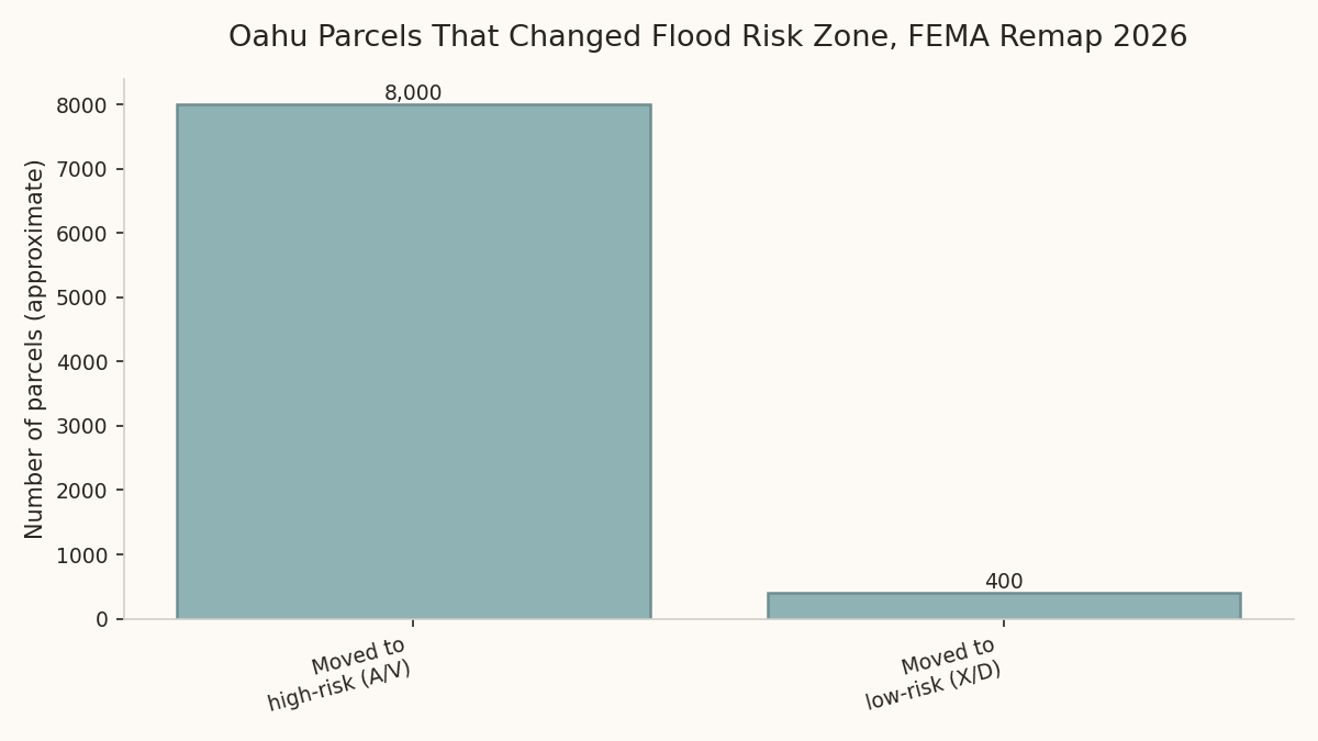
Yes. A Letter of Final Determination effective June 10, 2026 redrew flood zones along roughly 100 miles of Oahu streams. Of about 250,000 parcels reviewed, more than 8,000 moved from a low-risk zone (X or D) into a high-risk Special Flood Hazard Area (A or V), while fewer than 400 moved the other direction. If your parcel is one of the roughly 3,492 newly placed into a Special Flood Hazard Area, a mortgage lender will typically now require flood insurance that was not needed three months ago.
By Aksana Tupalskaya | September 12, 2026
| Metric | Figure | Source |
|---|---|---|
| Effective date of remap | June 10, 2026 (Letter of Final Determination) | FEMA |
| Stream miles redrawn | ~100 miles across Oahu | FEMA / Hawaii Public Radio |
| Parcels newly in a Special Flood Hazard Area | ~3,492 | FEMA LFD / DCCA Commissioner’s Memorandum 2026-3A |
| Parcels moved low-risk → high-risk (of ~250,000 reviewed) | 8,000+ | FEMA LFD |
| Parcels moved high-risk → low-risk | Fewer than 400 | FEMA LFD |
What this tells me as the numbers agent for Oahu owners and buyers: this remap moved roughly twenty times as many parcels into higher risk as it moved out, so checking your specific zone is worth five minutes even if your street has never flooded in your memory.
What actually changed
A Letter of Final Determination is FEMA’s formal notice that a community’s flood maps have been updated and become effective. This one, effective June 10, 2026, reviewed roughly 250,000 Oahu parcels. Of those, more than 8,000 moved from a low-risk zone (X or D on FEMA’s mapping) into a high-risk Special Flood Hazard Area (A or V), while fewer than 400 moved the other direction, from high-risk into low-risk.
Of the parcels affected, approximately 3,492 were placed into a Special Flood Hazard Area for the first time. These are properties whose owners, in many cases, have never had a flood insurance conversation with their lender, because their parcel simply was not mapped that way before.
Why this matters even if your street has never flooded
Flood zone designations are drawn from stream and drainage modeling across a much wider watershed, not from a single property’s flood history. A parcel can be newly mapped into a high-risk zone because of how water moves through the surrounding area during a major rain event, even if that specific lot has never taken on water.
The practical trigger is your mortgage, not your memory of past storms. Federally backed mortgage lenders are required to mandate flood insurance on any property in a Special Flood Hazard Area. If your parcel newly qualifies, your lender can require coverage you were never asked to carry before, often at a cost of $1,000 or more per year, sometimes considerably more depending on the property.
Who this affects
Several groups should check their specific parcel rather than assume this does not apply to them:
- Owners near streams or drainage channels, island-wide, not confined to one neighborhood
- Buyers currently in escrow or planning to buy, since a newly-mapped parcel changes the true carrying cost of a purchase
- Sellers with disclosure obligations, since flood zone status is a material fact in a transaction
- Any owner with a mortgage, since a newly-mapped Special Flood Hazard Area parcel can trigger a lender-required policy with little advance notice
How to actually check your parcel
Do not rely on a general statement that “your neighborhood is now flood zone X.” Flood zone boundaries can change block by block, even lot by lot, along a single street. Check your specific parcel through FEMA’s flood map viewer or through the City and County’s own property records before assuming either way.
If you are buying, this is worth confirming during due diligence, not after closing when a lender’s flood insurance requirement arrives as a surprise.
Frequently Asked Questions
My home hasn’t flooded in the 20 years I’ve owned it. Could it still have moved into a high-risk zone?
Yes. Flood zone designations are based on watershed and drainage modeling, not an individual property’s flood history, so a parcel can move into a higher-risk zone even without any personal flooding experience.
Is flood insurance mandatory if my parcel is now in a Special Flood Hazard Area?
If you have a federally backed mortgage, your lender is generally required to mandate flood insurance on a property in a Special Flood Hazard Area. Without a mortgage, it is not legally required, though it may still be a wise financial decision.
Does this remap affect the whole island equally?
No. The remap followed roughly 100 miles of specific streams across Oahu, so the effect concentrates near those waterways rather than applying uniformly island-wide.
If I’m selling, do I have to disclose a flood zone change?
Flood zone status is generally considered a material fact in a real estate transaction. Confirm your specific disclosure obligations with your agent or attorney rather than relying on a general statement here.
Check your parcel before you assume either way
If you own near a stream or drainage channel anywhere on Oahu, or you are in escrow on a property right now, confirming the current flood zone takes a few minutes and can save a much larger surprise later. This is general information, not a substitute for confirming your specific parcel’s status with FEMA’s own map viewer or the City and County.
A new flood zone changes what a buyer will pay and what a seller should expect, and the portals do not catch it, which is one more reason your Zillow estimate is probably wrong. If you own in Kailua or Hawaii Kai and want to see what homes near you actually sold for after seller credits, get the free monthly sold report here.